Bridge Mountain: A Technical Climbing Route, Not a Casual Hike
This is not a hike, and this guide is not written the way LvLocal's other Red Rock Canyon guides are. Bridge Mountain requires genuine Class 3-4 scrambling to reach its summit — a natural sandstone arch eroded into the rock — including a steep, near-vertical chimney climb that some route descriptions note has a fixed chain for aid, exposed slickrock, a crack climb, and a difficult ridge. This terrain is used as training ground by expert free-soloists. If you are a fit, prepared hiker without scrambling or climbing experience, this is not the trail for you — the North Peak Trail, also strenuous but hikeable, is a more appropriate objective in this same area. What follows is factual information for hikers with real scrambling/climbing experience who want to know what they're getting into, not an invitation for casual visitors.
Trail Snapshot
Distance | Two genuinely different approaches exist: 15.8 miles round trip via Willow Spring Picnic Area/Rocky Gap Road (official redrockcanyonlv.org figure), or 12.0 miles round trip via Lovell Canyon Road (AllTrails) — these are different routes, not a measurement discrepancy
Difficulty | Technical (Class 3-4 scrambling required, not standard hiking difficulty)
Hike Time | 6–7 hours (official figure, Willow Spring approach) — likely longer given the technical terrain
Elevation | Summit elevation 6,958+ ft; total gain not officially stated
Fee | $20 per vehicle if using the Willow Spring/Scenic Drive approach
Reservation | Required Oct 1–May 31, 8am to 5pm if using the Scenic Drive approach (free, via recreation.gov)
Restrooms | Yes, at Willow Spring Picnic Area (if using that approach); none beyond the trailhead
Difficulty | Technical (Class 3-4 scrambling required, not standard hiking difficulty)
Hike Time | 6–7 hours (official figure, Willow Spring approach) — likely longer given the technical terrain
Elevation | Summit elevation 6,958+ ft; total gain not officially stated
Fee | $20 per vehicle if using the Willow Spring/Scenic Drive approach
Reservation | Required Oct 1–May 31, 8am to 5pm if using the Scenic Drive approach (free, via recreation.gov)
Restrooms | Yes, at Willow Spring Picnic Area (if using that approach); none beyond the trailhead
Two Different Approaches — Don't Mix Them Up
The official park page describes a 15.8-mile round trip from Willow Spring Picnic Area via Rocky Gap Road, the same approach as LvLocal's North Peak Trail guide, splitting off at a shared junction. AllTrails instead describes a shorter 12.0-mile route via Lovell Canyon Road, an entirely different access road on another side of the range. Confirm which approach you're planning before you go, and don't mix directions from the two.
What the Climb Actually Involves
The official park page's only guidance is that "portions of this trail are unmarked and require scrambling" — it directs hikers to ask the Visitor Center for a detailed description rather than stating the specifics itself. Climbing-community sources are far more specific: expect a Class 3 scramble at minimum, including steep free-climbing down a chimney, slickrock, a crack climb, a difficult ridge, and climbing over obstacles like a fallen tree. Some route descriptions place the crux at Class 3-4 with a fixed chain for aid on the steepest section. Real fall exposure exists on the technical sections, and this terrain is used by expert free-soloists as training ground — a strong signal of how serious it is.
The Natural Arch
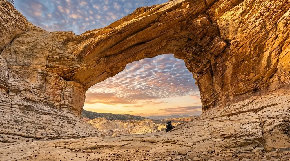
The "bridge" this peak is named for is a natural sandstone arch near the summit, described as the eroded remnant of a tinaja (natural rock water tank) wall. No span or height measurements are documented in available sources. The summit area also offers views over the surrounding Rainbow Mountains wilderness.
Who This Is For
This is a legitimate technical objective for experienced scramblers and climbers, and a genuinely inappropriate one for typical park visitors. Cell service is unreliable to nonexistent, and summer heat on this exposed, remote route is a genuine life-safety risk on top of the technical difficulty. Do not attempt this without genuine scrambling/climbing experience, a partner, proper footwear, and a clear turnaround plan.
Practical Advice
- Real scrambling/climbing experience is not optional for this route.
- Bring at least 3 to 4 liters of water per person.
- Go with a climbing partner, not solo.
- Wear proper footwear for slickrock and technical sections.
- Carry GPS/navigation, since portions are unmarked.
- Confirm which of the two approaches (Willow Spring vs. Lovell Canyon Road) you're taking before you go.
- Attempt this fall through spring only — summer heat here is dangerous independent of the technical difficulty.
- If you're unsure whether you have the experience for this, you don't. Choose North Peak Trail or Turtlehead Peak instead.
Bridge Mountain is real technical terrain in a park mostly known for hiking, not climbing. Respect what it actually requires, go with the right experience and partner, and if any part of this description gives you pause, that pause is correct — pick a different trail.