Bristlecone Trail: What to Know Before You Go
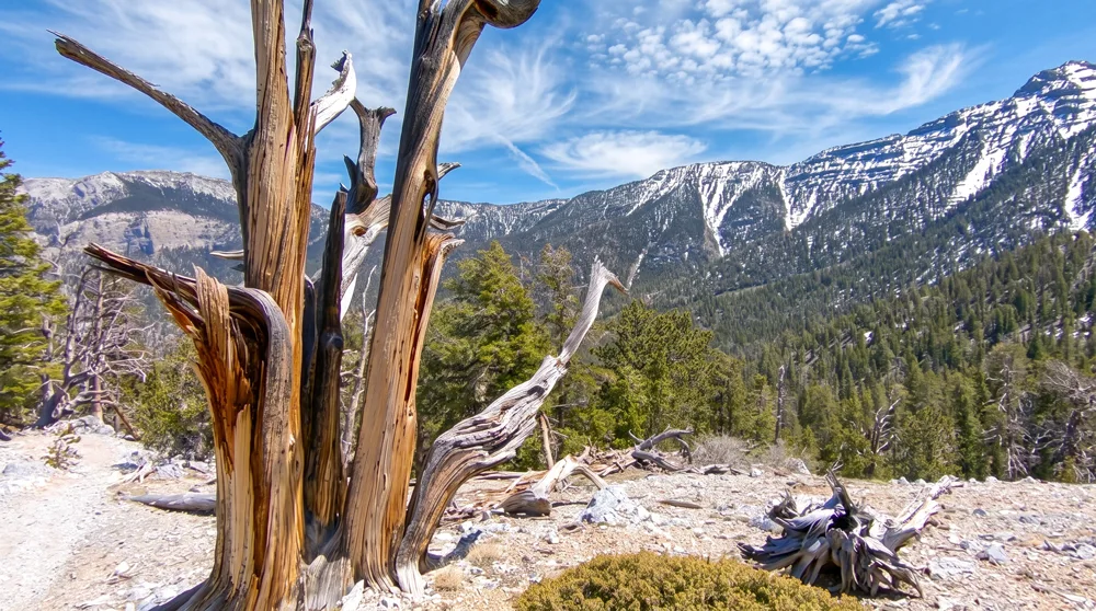
At over 8,000 feet, the air here smells like pine instead of dust, and the trees themselves are older than most human civilizations. Bristlecone pines are among the longest-lived organisms on Earth, and the trail bearing their name climbs into the Spring Mountains to reach them, following the final stretch of an abandoned 1930s-era road built by Works Progress Administration crews. It's a serious change of scenery from anywhere else on this list — forested, cool, and quiet, a world away from the desert floor thousands of feet below. Welcome to the Bristlecone Trail, one of the most physically demanding hikes near Las Vegas and one of the only places nearby where you can walk among trees old enough to have been alive before the pyramids.
Before You Go: The Upper Bristlecone Trail has been closed since Tropical Storm Hilary caused severe damage in August 2023, and the U.S. Forest Service does not expect it to reopen until 2029. Only the Lower Bristlecone Trail, reached via Scout Canyon Road, is currently open, and it now functions as an out-and-back rather than the historic loop. Some third-party trail apps still describe the full loop as hikeable — that information is outdated. Check the U.S. Forest Service's Bristlecone Trail page for current status before you go.
Trail Snapshot
Distance | Lower Bristlecone Trail (out-and-back) — a long, strenuous hike; confirm current mileage with the Forest Service, since the closure changed this from the historic loop
Difficulty | Strenuous
Hike Time | Plan for 3+ hours
Fee | None
Trail Status | Lower Trail open; Upper Trail closed until 2029
Elevation | Above 8,000 ft throughout
Restrooms | Not confirmed at the Lower trailhead — plan accordingly
Pets | Allowed, must be leashed
Best Season | Late spring through fall, snow-dependent
Difficulty | Strenuous
Hike Time | Plan for 3+ hours
Fee | None
Trail Status | Lower Trail open; Upper Trail closed until 2029
Elevation | Above 8,000 ft throughout
Restrooms | Not confirmed at the Lower trailhead — plan accordingly
Pets | Allowed, must be leashed
Best Season | Late spring through fall, snow-dependent
How to Reach the Trailhead
Access the Lower Bristlecone Trail via Scout Canyon Road, off Lee Canyon Road (NV-156), about an hour's drive northwest of Las Vegas. The historic Upper Bristlecone Trailhead, at roughly 8,650 feet, remains closed to through-hikers while storm-damage repairs continue. There's no fee to hike here, and no permit is required outside the designated wilderness area. Confirm current road and trail conditions before you drive up, since access details can change while the closure remains in effect.
What to Expect on the Trail
The Lower Bristlecone Trail climbs through a mixed forest of fir and aspen before the vegetation thins into the sparse, wind-scoured terrain where bristlecone pines take hold. For its final stretch, the historic route follows the remains of a Works Progress Administration-era road built in the 1930s — a rare piece of New Deal-era infrastructure still visible underfoot. Because the historic loop is currently broken by the Upper Trail's closure, plan your hike as an out-and-back: go as far as conditions and your own pace allow, then retrace your steps rather than expecting to complete a full circuit.
Ancient Trees and a New Deal-Era Road
Great Basin bristlecone pines are among the oldest living organisms on Earth, with individuals in the broader Spring Mountains range documented at well over a thousand years old. Their gnarled, wind-sculpted shapes are a direct result of the harsh, high-elevation conditions that also explain their longevity — slow growth in poor soil and thin air means less vulnerability to rot, fire, and insects over the centuries. The trail's approach follows the grade of an abandoned road built by Works Progress Administration crews in the 1930s, one of the New Deal's many public works projects across the Spring Mountains, adding a layer of Depression-era history to the ancient trees above.
Best Time to Visit and Conditions
Late spring through fall is the only realistic window, once snow clears from the high-elevation trailhead and before it returns. Summer offers the most reliable access and the biggest temperature contrast with the Las Vegas valley below, though afternoon thunderstorms are common at this elevation, so plan to be off any exposed ridge by early afternoon. Given the Upper Trail's extended closure, check current conditions on the Lower Trail specifically before planning a trip, since access details may continue to change through the 2029 target reopening.
Practical Advice for New Visitors
- Confirm current trail status on the Forest Service website before you go — the Upper Trail closure has changed this hike from a loop to an out-and-back.
- Bring at least 3 liters of water per person given the length and elevation.
- Pack real layers — temperatures here run dramatically cooler than the Las Vegas valley.
- Wear broken-in hiking boots; this is a long trail with variable footing.
- Watch for afternoon thunderstorms in summer and turn back early if weather builds.
- The altitude is noticeable if you're not acclimated — pace yourself, especially early on.
- Leash your dog; wildlife encounters are more likely in forested terrain than in the desert.
- There's no food or reliable water source on the trail — bring everything you need.
The Bristlecone Trail offers something no desert hike near Las Vegas can match: real forest, real elevation, and trees that have been standing since long before Las Vegas existed at all. The ongoing closure of the Upper Trail is a real limitation right now, not a footnote, so go in with accurate expectations, check current conditions before you drive up, and treat these ancient, slow-growing trees with the same care you'd want extended to something that took a thousand years to get where it is.