Northern Bowl of Fire: What to Know Before You Go
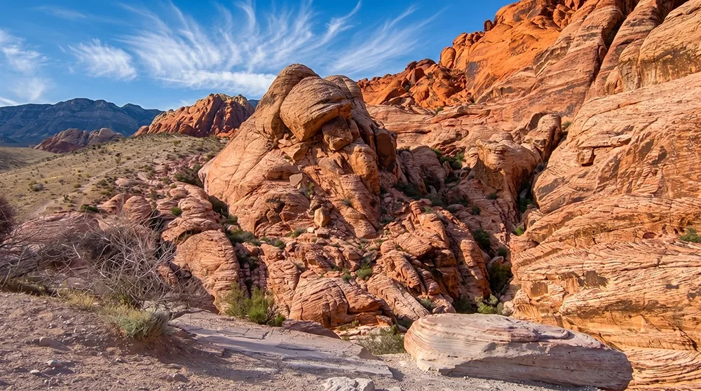
The Northern Bowl of Fire is a genuine amphitheater of fiery red Aztec sandstone, with pockets of yellow, pink, and orange, dramatically different from the gray limestone hills surrounding it. How far you go determines the distance — shorter turnarounds at the first outcropping run around 2.2 miles round trip, while pushing to a full 360-degree viewpoint over the Overton Arm can stretch past 8 miles. There's no fully marked path beyond the initial approach, so real navigation matters. Welcome to the Northern Bowl of Fire, one of the most photogenic off-trail hikes near Lake Mead.
Trail Snapshot
Distance | Roughly 2.2 to 8 miles round trip depending on how far into the bowl you go
Elevation | Varies significantly by route (roughly 1,000–2,500 ft cumulative on the longer options)
Difficulty | Moderate to Strenuous depending on distance chosen
Hike Time | 1.5 to 5 hours depending on distance chosen
Fee | $25 per vehicle (1-7 day pass), $15 per person pedestrian/cyclist, $45 annual pass — cashless, card only
Restrooms | Not confirmed at the trailhead
Pets | Not explicitly confirmed
Elevation | Varies significantly by route (roughly 1,000–2,500 ft cumulative on the longer options)
Difficulty | Moderate to Strenuous depending on distance chosen
Hike Time | 1.5 to 5 hours depending on distance chosen
Fee | $25 per vehicle (1-7 day pass), $15 per person pedestrian/cyclist, $45 annual pass — cashless, card only
Restrooms | Not confirmed at the trailhead
Pets | Not explicitly confirmed
How to Reach the Trailhead
Park at the Northshore Summit Trail parking area near mile 20 on Northshore Road. A shorter variant of this hike may start from an unmarked pullout closer to mile 18.2 — sources aren't fully consistent on this, so treat the exact starting point as somewhat flexible depending on how far you plan to go. Lake Mead National Recreation Area's entrance fee ($25/vehicle) applies.
What to Expect on the Trail
One detailed trip account describes leaving the established approach, getting turned around, and relying on a cairn to find the way back — a real, documented navigation challenge beyond the first section. Distance genuinely varies from about 2.2 to 8 miles round trip across different sources, most likely reflecting different turnaround points within the same general bowl rather than fully separate trails. Little shade exists anywhere on this route, and you should stay on established paths where they exist to avoid trampling fragile cryptobiotic soil crust, a living surface that takes decades to regenerate once disturbed.
A Frozen Dune Field in Red Rock
The Northern Bowl of Fire's amphitheater is a massive Aztec sandstone formation, made from frozen Jurassic-era sand dunes, with red coloring from iron that leached through the sand before it solidified — part of the same geological system that colors Valley of Fire. The longer route's viewpoint takes in the Overton Arm of Lake Mead, Hamblin Mountain, the Southern Bowl of Fire, Anniversary Ridge, and the Muddy Mountains.
Best Time to Visit and Conditions
Spring is specifically recommended for beavertail cactus blooms; fall and winter are also comfortable given the exposed terrain.
Practical Advice for New Visitors
- Bring at least 2-3 liters of water per person.
- Download a GPS track or offline map for the longer route.
- Wear sturdy boots and long pants for scrambling sections.
- Decide your turnaround point before you start.
- Stay on established paths to protect fragile cryptobiotic soil crust.
- This route requires real navigation beyond the initial approach — a cairn or GPS track helps.
- Time a spring visit around the beavertail cactus blooms.
- Not appropriate for young kids on the longer route given the off-trail navigation.
For hikers willing to embrace some genuine route-finding, the Northern Bowl of Fire delivers dramatic red-rock scenery that rivals Valley of Fire, without the crowds. Pick your distance honestly, bring real navigation tools, and tread lightly on the fragile desert crust along the way.